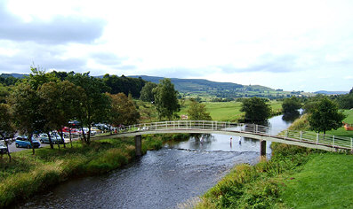
The Haugh
The Heritage Trail starts at
the Cow Haugh Car Park on the south bank of the River Coquet and overlooked by
Simonside, the Sacred Mountain.
So where did the names come from? Well, in a document dated 1292 the Sacred Mountain was called "Simundessete and by 1580 this had changed to "Simonside". It is thought that the name is possibly a corruption of "Sigemund's Seat" or "Settlement" and it has been suggested that this is the Sigmund mentioned in the great Anglo Saxon Poem, Beowulf.
Tomlinson seems to prefer
"Simon's sete or settlement"
while others prefer a derivation from "Sailor's sight" as it can be clearly seen
from
 the
coast. In fact this is mentioned in a poem hanging in the Newcastle Hotel:
the
coast. In fact this is mentioned in a poem hanging in the Newcastle Hotel:
|
"Oh purple
hills of Simonside. Ye olde times sailors guide. |
And "Coquet"? Paul Frodsham suggests it is derived from "Coccoveda", the earliest known reference to the Coquet, from the Celtic word "cochwedd" meaning "red appearance", reflecting the red pebbles that litter its bed.
So take your pick. Whatever the reason it seems buried in history.
You might be interested to know that although it is probably the best known mountain in the area, Simonside is not the highest. This honour goes to Tosson Hill about half a mile to the west, which at 440 metres tops it by about 11 metres. Not really worth worrying about and depending on your definition it may not even be a mountain. The Department for Environment, Food and Rural Affairs has defined "mountain" as all land over 600 metres for the purposes of right to roam legislation. But why should we care.
It has been our Sacred Mountain for ever and will remain so.
'Haugh' comes from the old English 'halh' and means a riverside meadow or flat area. Originally cattle grazed this area, and the land to the west, where the golf course now stands, was a steeplechase course for over two hundred years.
The first official race was held on April 28th 1762 and the last race was on April 10th 1965 two years after the last freight train and thirteen years after the last passenger train to Rothbury.
Just up from the Haugh in the direction of the cemetery is the Rothbury Hospital. Its garish lights have been toned down a little but the building with its flat roof, wooden slats and coloured walls looks completely out of place with its surroundings. How it ever got planning permission in a conservation area remains a mystery.
There is a popular story that Prince Charles was invited to open it, but on arrival was so disappointed that he opted to open the newly refurbished Jubilee Hall instead. However it must be said that the interior layout and decor is excellent. As indeed are the facilities. And we are pleased to have it.
The old golf clubhouse
originally accessed by a rather insubstantial looking bridge across the Coquet
is now redundant. A brand new clubhouse was opened a little to the south of the
hospital.
A modern building that blends in well with its surroundings, it faces the setting sun and has a superb view down the valley.
This new facility is a great asset to the village. The course has been improved and now boasts 18 holes. Visitors are always welcome.
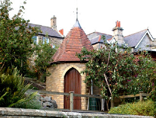
The house nearest the old closed cemetery on the north of the river boasts a 'Game Store' bought at the Newcastle Exhibition in 1926 and which can just be seen over the high wall. It is the only remaining one of its kind in the village.
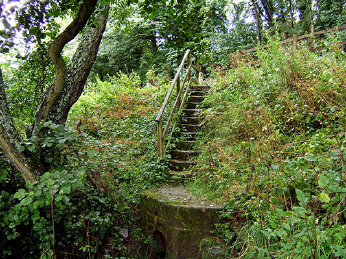 Donkin's
Well, to the east and reached down some stone steps is pure spring water and was
one of the first sources of fresh water in the district, prior to the
availability of mains. The steps are rather overgrown and the slight
trickle does not seem to be able to provide a great flow.
Donkin's
Well, to the east and reached down some stone steps is pure spring water and was
one of the first sources of fresh water in the district, prior to the
availability of mains. The steps are rather overgrown and the slight
trickle does not seem to be able to provide a great flow.
Continue east towards the Bridge.